GEOVIA
Powered by the 3DEXPERIENCE platform, GEOVIA provides end-to-end digital solutions focusing on the intersection of natural resources, infrastructure and urban planning. We empower a diverse community of geoscientists, earth engineers, and urban planners to access the information and insights they need to make informed decisions that balance economic, environmental, and social considerations, ensuring the responsible use and development of the Earth’s resources.
With GEOVIA, you can:
- Create detailed models from accurate, auditable, and secure data
- Generate robust plans you can rely on
- Unlock more value by bringing people and data together in a contextualized environment
- Reduce risk by simulating your operation before making key decisions
- Support and engage employees, suppliers, communities, and customers by offering a single, unified source of truth on your operation
- Improve collaboration and transparency across disciplines, locations, and organizations for the life of your operation
The GEOVIA portfolio is a comprehensive suite of software tools designed to optimize mining operations and enhance decision-making in the mining industry. It consists of several powerful applications, including Surpac, Minesched, and Whittle, and the roles in the 3DEXPERIENCE platform.
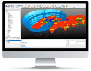 GEOVIA Surpac provides mining companies with the powerful, reliable, and customizable 3D mine planning and geological modeling software they need to perform rigorous drillhole data, statistical, and geostatistical analyses, and to develop comprehensive resource models, mine designs, and mine plans for either open pit or underground operations.
The most popular geology and mine planning software in the world, GEOVIA Surpac addresses all the requirements of geologists, surveyors, and mining engineers in the resource sector through powerful 3D graphics and workflow automation. With Surpac, geologists can quantify and evaluate the physical characteristics of a deposit, even with limited information. Engineers can visualize mine designs and plans that maximize ore recovery while complying with project constraints. Mine production teams can integrate vast amounts of data to determine the best way to extract reserves.
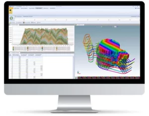 GEOVIA MineSched makes developing a tactical mine plan — a plan that turns the decisions defined in a strategic mine plan into a schedule to guide day-to-day operations — easy by providing intuitive, rapid setup, and guided workflows that enable the creation of target-based, long- and short-term schedules from pre-created block and polygon models.
MineSched is a scheduling software for surface and underground mines that allows companies to develop practical, tactical schedules to maximize productivity and minimize cost. Intuitive, rapid setup and guided workflows take the complexity out of tactical mine planning and put the decision-making power back in the hands of engineers and mining operations to produce long and short-term schedules that meet capacity and material quality targets. MineSched can schedule from pre-created block, and polygon models that originate from many different mine planning systems, including GEOVIA Surpac.
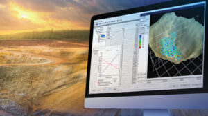 GEOVIA Whittle helps mining companies first evaluate the financial viability of a mineral deposit, then determine the optimal mine strategy not only to extract that deposit but also to establish the best possible life-of-mine schedule.
This industry-leading strategic mine planning solution helps exploration and mining companies evaluate the financial viability and optimal mine strategy for a deposit. Considering real mining constraints, it can help determine investment strategy and deliver robust mine plans that maximize profitability. Whittle delivers trusted results and is used in scoping, feasibility, life-of-mine scheduling, and the ongoing
re-evaluation of mine plans through the production phase to closure. Whittle provides an integrated suite of tools to optimize the mining value chain, enabling significant project value increases over and above pit optimization.

RELATED PRODUCTS
Learn more about related products where RESPEC has proven our expertise in this area.
")

Stay in Touch